No edit summary |
Firstordermen (talk | contribs) No edit summary Tag: Source edit |
||
| (42 intermediate revisions by 10 users not shown) | |||
| Line 1: | Line 1: | ||
| + | {{District| |
||
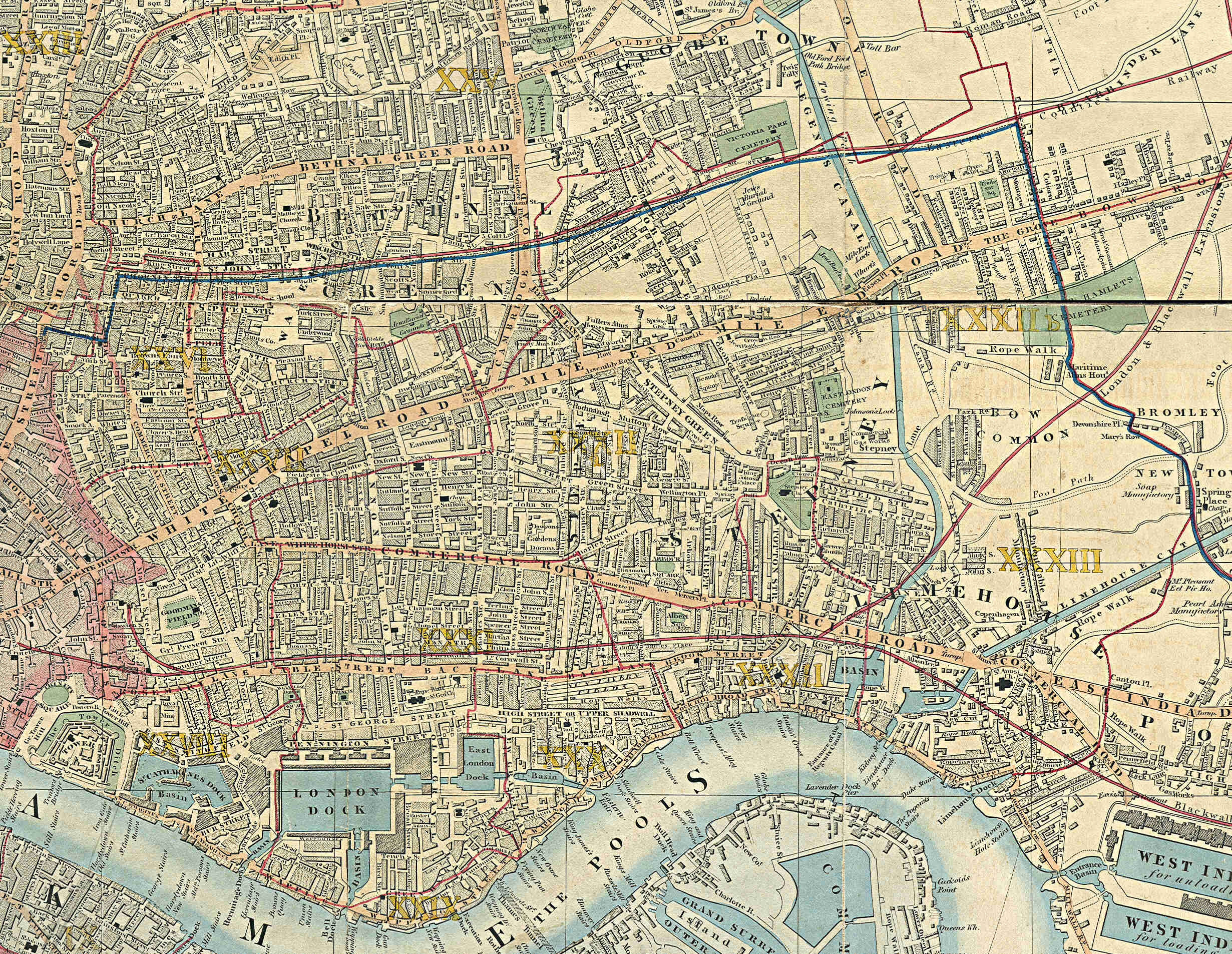
| − | '''Stepney''' is a district in the [[London Borough of Tower Hamlets]] in London's [[East End]] that grew out of a medieval village around St Dunstan's church and the 15th century ribbon development of [[Mile End Road]]. The area built up rapidly in the 19th century, mainly to accommodate immigrant workers and displaced London poor, and developed a reputation for poverty, overcrowding, violence and political dissent. [[Bethnal Green]] is located to the north, [[Limehouse]] and [[Mile End]] is east, [[Rotherhithe]] to the south, [[Whitechapel]] and [[Shadwell]] to the east. Stepney includes [[Arbour Square]], [[Stepney City Farm]], and [[George Tavern]]. |
||
| + | |name= Stepney | |
||
| + | |image=| |
||
| + | |map= | |
||
| + | |population= | |
||
| + | |postcode_district= E1, E14| |
||
| + | |borough= [[London Borough of Tower Hamlets]] | |
||
| + | |os_grid_reference= | |
||
| + | |latitude= | |
||
| + | |longitude= | |
||
| + | }} |
||
| + | '''Stepney''' is an area in [[East London|East]] [[London]], located in the [[London Borough of Tower Hamlets]]. The district is no longer officially defined, and is usually used to refer to a relatively small area. [[Stepney Green]] is a remnant of a larger area of Common Land formerly known as [[Mile End]] Green and is sometime regarded as a separate area. |
||
| − | == |
+ | ==History== |
Stepney formed a [[Stepney (parish)|large ancient parish]] in the [[Ossulstone]] hundred of [[Middlesex]]; bounded by [[Bromley-by-Bow|Bromley]] and [[West Ham]] to the east, the [[River Thames]] to the south, [[Shoreditch (parish)|Shoreditch]] and [[Hackney (parish)|Hackney]] to the north and the [[City of London]] and the [[Liberties of the Tower of London]] to the west. The parish included the hamlets of [[Mile End Old Town]], [[Mile End New Town]], and [[Ratcliff]]. At its early extent it additionally included [[Whitechapel]], [[Wapping]], [[Bow, London|Stratford Bow]], [[Shadwell]], [[Spitalfields]], [[Bethnal Green]], [[Limehouse]] and [[Poplar, London|Poplar]]. Over time the parish was broken up with these settlements forming new independent parishes, leaving a residual parish of 830 acres comprising Mile End Old Town, Mile End New Town and Ratcliff |
Stepney formed a [[Stepney (parish)|large ancient parish]] in the [[Ossulstone]] hundred of [[Middlesex]]; bounded by [[Bromley-by-Bow|Bromley]] and [[West Ham]] to the east, the [[River Thames]] to the south, [[Shoreditch (parish)|Shoreditch]] and [[Hackney (parish)|Hackney]] to the north and the [[City of London]] and the [[Liberties of the Tower of London]] to the west. The parish included the hamlets of [[Mile End Old Town]], [[Mile End New Town]], and [[Ratcliff]]. At its early extent it additionally included [[Whitechapel]], [[Wapping]], [[Bow, London|Stratford Bow]], [[Shadwell]], [[Spitalfields]], [[Bethnal Green]], [[Limehouse]] and [[Poplar, London|Poplar]]. Over time the parish was broken up with these settlements forming new independent parishes, leaving a residual parish of 830 acres comprising Mile End Old Town, Mile End New Town and Ratcliff |
||
| Line 11: | Line 22: | ||
==Transport== |
==Transport== |
||
| − | + | Close to Arbour Square, on Commercial Road, [[London Buses]] east to west routes, these are the [[London Buses route 15|15]], 115, [[London Buses route 135|135]] and N550.<ref>{{cite web |url=https://tfl.gov.uk/bus/stop/490012669E/stepney-methodist-church?lineId=n15 |title=Stepney Methodist Church |website=Transport for London}}</ref> |
|
| + | |||
| + | Further routes is the 309 (running east-north) and 339 (south-east) via Ben Johnson Road.<ref>{{cite web |url=https://tfl.gov.uk/bus/stop/490003897W/harford-street |title=Harford Street |website=Transport for London}}</ref> |
||
| + | [[Category:Areas in Tower Hamlets]] |
||
| − | The area overall is covered by [[London Buses]] services, mostly west-east by the [[London Buses route 25|25]], 205, N205 on Mile End Road<ref>{{cite web|url=https://tfl.gov.uk/bus/stop/490G00220E1/stepney-green-station |title=Stepney Green Station |website=Transport for London}}</ref>and [[London Buses route 15|15]], 115, [[London Buses route 135|135]] and N550 on Commercial Road<ref>{{cite web |url=https://tfl.gov.uk/bus/stop/490012669E/stepney-methodist-church?lineId=n15 |title=Stepney Methodist Church |website=Transport for London}}</ref>, the 309 and 339 via Ben Johnson Road.<ref>{{cite web |url=https://tfl.gov.uk/bus/stop/490003897W/harford-street |title=Harford Street |website=Transport for London}}</ref> |
||
[[Category:London Borough of Tower Hamlets]] |
[[Category:London Borough of Tower Hamlets]] |
||
[[Category:Liberties of London]] |
[[Category:Liberties of London]] |
||
| + | [[Category:Stepney]] |
||
| + | From the Wikipedia page [https://en.wikipedia.org/wiki/Stepney] |
||
Revision as of 12:22, 18 January 2022
| DISTRICT | ||
| Stepney | ||
|---|---|---|
| Image | ||
| Population | ||
| PostCode District | E1, E14 | |
| Borough | London Borough of Tower Hamlets | |
| OS Grid Reference | ||
| Latitude | ||
| Longditude | ||
Stepney is an area in East London, located in the London Borough of Tower Hamlets. The district is no longer officially defined, and is usually used to refer to a relatively small area. Stepney Green is a remnant of a larger area of Common Land formerly known as Mile End Green and is sometime regarded as a separate area.
History
Stepney formed a large ancient parish in the Ossulstone hundred of Middlesex; bounded by Bromley and West Ham to the east, the River Thames to the south, Shoreditch and Hackney to the north and the City of London and the Liberties of the Tower of London to the west. The parish included the hamlets of Mile End Old Town, Mile End New Town, and Ratcliff. At its early extent it additionally included Whitechapel, Wapping, Stratford Bow, Shadwell, Spitalfields, Bethnal Green, Limehouse and Poplar. Over time the parish was broken up with these settlements forming new independent parishes, leaving a residual parish of 830 acres comprising Mile End Old Town, Mile End New Town and Ratcliff
Stepney is an episcopal area in the Anglican Diocese of London, which covers the London boroughs of Hackney, Islington and Tower Hamlets, and has its own suffragan bishop.
The Metropolitan Borough of Stepney was formed in 1900, then dissolved in 1965 when it was absorbed into the newly created London Borough of Tower Hamlets which currently administers the area
Transport
Close to Arbour Square, on Commercial Road, London Buses east to west routes, these are the 15, 115, 135 and N550.[1]
Further routes is the 309 (running east-north) and 339 (south-east) via Ben Johnson Road.[2] From the Wikipedia page [1]